A sweet convergence line set up over the whole coastal range, allowing me to fly from Mt. St. Helena to I-680 east of Vallejo.
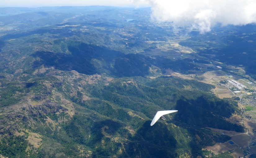
I launched at 12:15 and immediately climbed out over the mountain and above the lower cloudbase on the marine side of the convergence. I hung out over the mountain until Scot launched and climbed to join me, then we headed toward the Palisades at cloudbase. We worked a thermal together after crossing CA-29 and I snapped some pictures of him before we set off on glide.
That was the last we saw of each other, as he took the east route around some lower clouds and I took the west route. I thought I saw obvious signs of a thermal triggering off north of the town of St. Helena (change in wind direction indicated by smoke and ripples on a nearby lake) and sped towards it over the Napa Valley. Unfortunately when I got there I found nothing but sink.
I picked out a couple of fields on the south side of town and started preparing to land in one of them. When I arrived at my chosen field, I encountered some light lift and was able to climb back up to 4k, where it seemed to peter out. Analysis of my tracklog indicates that the wind switched from NNW to N and increased in velocity at that height. After some hunting around, I reconnected with the thermal and picked up another 1000′ as I drifted toward the hills.
It took me another glide to get back over the valley and a long drifting climb before I shifted my focus from landing options back to the clouds and what lay ahead on course. At some point during that climb, we decided that Matt, who was waiting in Napa, should continue chasing Scot out toward the Central Valley via CA-12 and worry about picking me up on the way back.
The clouds were all showing NNE wind aloft and I thought about hopping the ridge and pushing out across the Sonoma Valley toward Infineon Raceway. However, I figured there would be some significant SW wind at lower altitudes coming off San Pablo bay and fueling the convergence, so I decided to track CA-12 out toward Fairfield.
The transition over the south end of Napa was spectacular! I was flying at about 8k and skirting around building cumies well below an upper cloud layer. As I flew over the north end of Napa County Airport (well above the ceiling of it’s class D airspace), I looked down to see the sock indicating a stiff SW breeze.
I worked a few bubbles as I tracked the ridge north of CA-12 out toward I-80, but I arrived at Fairfield low and started setting up for landing. As I approached the freeway I caught another climb and soon found myself back in the northerly flow, drifting toward Suisun Bay.
I wasn’t sure about the extent of the controlled airspace around Travis AFB or the availability of roads and dry land out in the Delta, so I pushed back toward the hills east of Vallejo. I fought a pretty significant headwind and didn’t find any more lift on that transition, so I set up and landed in a field next to I-680, setting a new paraglider site record at 46.9 miles.
Scot landed somewhere near the Altamont Pass. I believe this was the first time anybody has crossed the Delta from St. Helena.
Tracklog: http://paraglidingforum.com/leonardo/flight/448874
3D Visualization: http://www.doarama.com/view/310367


